

Rivers not allowed to be rivers
One of the most distinguishing characteristics of our cities is their enviable location at the confluence of the lower Snake River and the Clearwater River.
Today, these rivers are not allowed to be rivers. The creation of Lower Granite Reservoir was the last step in converting 140 miles of free-flowing river into a series of stagnant reservoirs. This changed more than just the river. It changed life in our cities.
Photo Credit: Scott Putnam
Photo Credit: Scott Putnam
A Hostile Environment
Today, the water’s edge has become boring and hostile to both flora and fauna. No more gentle riverbanks with beaches, gravel bars and willow groves. We can no longer even see the river from downtown Lewiston. No longer do Lewiston residents and visitors have an idyllic view of the confluence of two amazing rivers: the Clearwater and Snake.
The levees are lined with angular boulders, called rip-rap, making it extremely dangerous for people to reach the water’s edge.
When I grew up in Lewiston in the 1950’s, the rivers were the heart of our community. Now we hardly know we are near water. I would love to see the river recovered, and with it a renewed, revitalized life for my hometown.
–Richard Scully, longtime Lewiston resident
The River – Then and Now
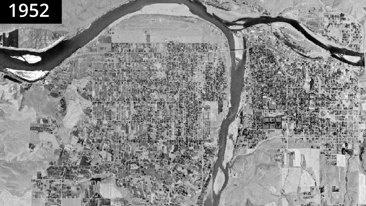
photo credit: https://www.landscapeexplorer.org/data/
This aerial view of the city of Lewiston in 1952 shows the lower Snake River occupying its natural channel. The lower Snake River flows from the bottom center of the photo up and then toward the left edge of the photo. The Clearwater River flows west toward the Snake, entering the photo from the right edge. Note the numerous islands and sandbars, providing a wealth of sandy beaches. While the photo was taken too far away for the rapids to be visible, there were many—even one class III rapid right in the city of Lewiston.
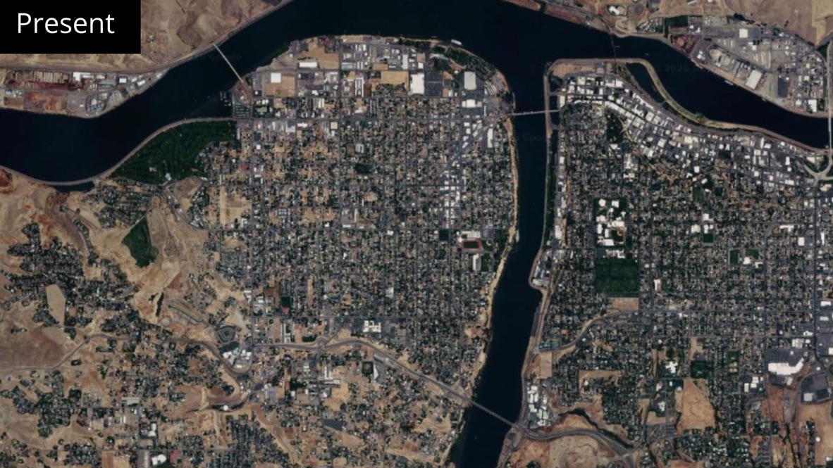
photo credit: https://www.landscapeexplorer.org/data/
This photo shows the same area today. Note how the flooded river-turned-reservoir occupies a much wider channel than the natural river did. One can see how the inundation eliminated all the beaches and sandbars that once characterized the river as it wrapped around the city. One can also see how the riparian zone (adjacent to the river in the 1952 photo) has been completely wiped out.
With a reservoir, USACE can make our beaches disappear
Photo Credit: Scott Putnam
Photo Credit: Scott Putnam
These two photos look quite different—one with a wide sandy beach being used by boaters, swimmers, jet skiers, motorboats, pontoon boats, tubers, and sunbathers—and the other having no beach at all. If you look closely, you will see that this is actually the same stretch of river, just in different years and representing different river levels as set by the Army Corps of Engineers (USACE). USACE is the entity that manages the dams and determines water levels. The photo on the left was taken in 2025 when the water level was held at the minimal level. The photo on the right was taken one year later (2026) when USACE raised the river level by 2-3’, causing this beach to completely disappear under the reservoir water.
When the riverbed was buried under the reservoir, riparian zones (the trees and bushes along the riverbank) disappeared. Losing these riparian zones resulted in a staggering loss of wildlife. In the first 12 years following the creation of Lower Granite Reservoir in 1975, flooding caused the loss of over 98% of our game birds, another 96% of our songbirds, and 96% or our fur-bearing animals.
“Struggle for the Snake.”
This is an old video (1971) produced by Washington State University during the construction of Lower Granite Dam which addresses the loss of wildlife resulting from construction of the dam.
Photo Credit: Scott Putnam
Salmon and Steelhead Population Impact
Salmon and steelhead populations declined drastically when the free-flowing river was replaced by the reservoirs. Fishing for these species is a mere fraction of what they used to be. Fishing seasons have been curtailed and even canceled in recent years, and we expect more of the same. Recreational fishing is big business in Idaho and Washington—and businesses felt the pinch when the number of fish declined so drastically.
The river itself suffered. Toxic algae blooms occur for months each summer, depriving the river of oxygen while forcing people and pets to stay away.
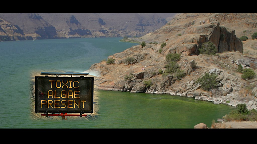
Toxic Algae Blooms
“Today, Lower Granite Reservoir provides the perfect ingredients for creating toxic algae blooms: stagnant, warm water fed by agricultural runoff. The bacteria in these blooms are highly toxic to humans, pets, livestock, and wildlife and can accumulate in fish. In 2023, such a bloom covered more than 30 miles of lower Snake River reservoirs, in some places shore-to-shore, prompting warnings from the Whitman County Public Health Department for people to keep themselves and their pets out of the water and not to eat any fish caught nearby.”
Jax
Toxic Algae Poisoning
2021 – 2024
Lower Columbia River
Loss of our free-flowing river impacted our quality of life in many negative ways. But we can regain access to our riverfronts and put these wildlife losses and water pollution in our rearview mirror, if we return the river to its natural, free-flowing state. See what the future holds for the Lewiston-Clarkston area.